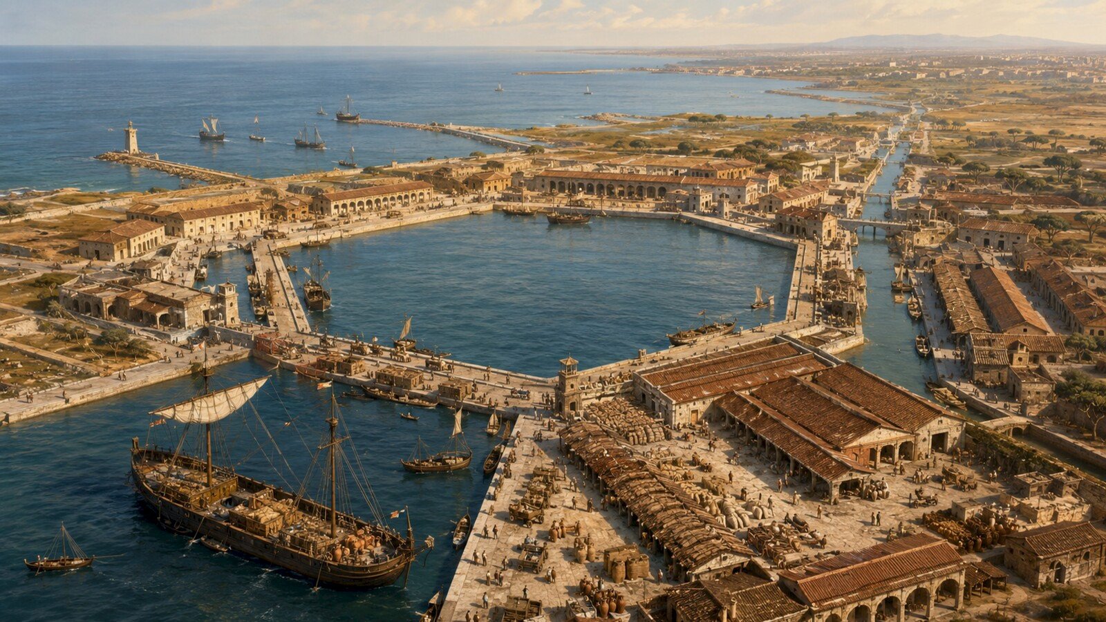
Approaching Rome from the Mediterranean in the second century CE, a merchant ship did not sail straight to the capital. Rome stood inland, more than twenty kilometres up the Tiber, and the river mouth at Ostia was shallow, changeable and difficult for the largest loaded vessels. The city that ruled a sea therefore depended on an artificial gateway built beside it.
That gateway was Portus. Emperor Claudius began the harbour in the middle of the first century CE; Trajan and Hadrian later transformed it around an unmistakable hexagonal basin. Ships arrived carrying grain, olive oil, wine, fish sauce, marble, ceramics and other goods from across the Roman world. Cargo then moved through quays, warehouses, canals, roads and river barges toward Rome.
Portus did not connect the Mediterranean by itself. It worked with Ostia and with hundreds of ports, farms, workshops, shipping routes and local markets. But it concentrated those relationships in one place. Its surviving basins, buildings, pottery and inscriptions allow archaeologists to reconstruct how imperial power became a daily logistics operation.
Rome had a geographical problem
Ostia had served Rome’s maritime traffic for centuries. Its position at the Tiber mouth made it a natural transfer point between sea and river, and the town developed warehouses, commercial districts, temples and homes. Yet the same environment imposed limits. Sediment accumulated, the lower river flooded, anchorage was restricted and heavily laden ships needed deeper, safer water.
The problem became more urgent as Rome grew. The capital could not obtain all its food and building materials from nearby land. Grain arrived especially from Egypt and North Africa; olive oil came in enormous quantities from southern Spain and North Africa; stone travelled from quarries around the Mediterranean. Moving bulk cargo by water was far cheaper than hauling it long distances over land.
Supply was therefore political. An interruption caused by storms, shipwreck, poor harvests or administrative failure could raise prices and provoke unrest. Emperors presented themselves as providers, but that promise depended on sailors, merchants, financiers, porters, warehouse workers, boatmen, officials and producers scattered across the provinces.
Portus turned Rome’s command of distant territory into something its population could eat, build with and use.
Claudius builds a harbour from the coast
Around the middle of the first century CE, Claudius commissioned a new harbour a few kilometres north of Ostia. Roman engineers cut a vast basin into the coast and protected its entrance with concrete moles. A lighthouse marked the approach from the Tyrrhenian Sea. The project was inaugurated under Nero after Claudius’s death.
This was not simply a sheltered patch of water. Quays received ships, storage buildings held cargo and canals linked the harbour zone to the Tiber. Large seagoing vessels could unload near the coast. Smaller river craft then carried goods inland, avoiding the need for deep-draught ships to navigate the lower river.
The canals served more than transport. Claudian works also helped direct water through the delta and were intended to reduce flooding. Portus was therefore an engineered system joining maritime access, river movement, drainage and storage. Its value came from the connections between those parts.
Claudius advertised the achievement. An inscription from a monumental arch commemorated the port, while imperial coins presented the harbour as proof that the emperor had secured Rome’s supply. Infrastructure solved a practical problem, but it also communicated authority: the ruler appeared capable of reorganising the coastline for the public good.
Trajan’s hexagon becomes a machine
By the early second century, the port was enlarged again. Under Trajan and Hadrian, probably between about 112 or 114 and 120 CE, workers excavated a new inner basin east of the Claudian harbour. Its six straight sides formed the shape that still identifies Portus from the air.
The hexagon was both memorable and practical. Straight quays created extensive berthing frontage around a protected interior. Ships and smaller craft could be positioned beside warehouses and handling areas, while several sides distributed activity instead of forcing every vessel through one narrow waterfront. NASA satellite imagery shows the surviving basin as a reed-fringed lake, now inland because the coastline has moved westward through centuries of sedimentation.
Around the water stood major buildings: warehouses, a temple precinct, administrative spaces, a possible imperial shipshed and the complex known as the Palazzo Imperiale. Archaeological work indicates that the palace-like structure covered about two hectares and rose to several storeys. Its mosaics, sculptures and commanding views expressed status, but offices and service areas tied it to the management of the port.
New road and canal links integrated the enlarged harbour with Rome, the Tiber and Ostia. The result was not the replacement of one port by another. Portus and Ostia operated as complementary parts of a wider system: maritime cargo handling and bulk storage were concentrated at Portus, while Ostia remained a thriving town, river port and commercial centre.
From an ocean-going ship to a Roman street
A cargo’s arrival was only one stage in its journey. A grain ship first needed a safe berth or anchorage. Its cargo had to be measured, inspected, recorded and moved without excessive loss. Grain required protection from moisture, pests and theft. Amphorae carrying oil, wine or fish sauce were heavy, breakable and shaped for transport rather than easy stacking on a flat floor.
Portus contained extensive horrea—storage buildings often arranged around courtyards or long internal routes. Thick walls, raised floors and controlled access could help protect commodities while officials and merchants managed their release. Modern study of warehouse plans suggests that Portus was especially oriented toward rapid turnover of bulk goods, while Ostia handled a broader range of products and storage practices.
From the harbour, cargo could move onto smaller boats suitable for the Tiber. Some were hauled upriver toward Rome. Other goods travelled by road or were redistributed through nearby markets and ports. This repeated transfer—from seagoing vessel to quay, store, barge and urban warehouse—required coordination rather than one spectacular invention.
The system was never frictionless. Weather delayed arrivals. Grain spoiled. Containers broke. Records could be disputed and workers could be injured. Efficient infrastructure reduced risk, but it did not remove uncertainty. Rome’s food security rested on maintaining spare capacity, storage and multiple routes across an unpredictable sea.
Pottery turns the harbour into a map
Much of what reached Portus has vanished. Grain was eaten, oil was poured out, textiles decayed and wooden ships were repaired or dismantled. Broken pottery survives in abundance. For archaeologists, a potsherd is not rubbish without meaning; its fabric, shape, surface and manufacturing marks can identify where and when a container was made.
Thousands of fragments found at Portus document long-distance movement. Amphorae carried olive oil, wine and fish sauce. Excavated material includes imports from Tripolitania in modern Libya, Roman Africa around modern Tunisia, southern Spain, southern Gaul, Greece, Egypt, Palestine and Asia Minor. In some excavated groups, Italian ceramics were comparatively rare.
That distribution changes the story of the harbour. Portus was not merely the endpoint of lines radiating from Rome. It joined regional production centres to a capital market and sometimes redistributed goods onward to other ports. Each container was part of a chain involving a farm or workshop, a kiln, a shipper, a vessel, harbour labour and a buyer.
Marble provides another kind of evidence. Stone from distant quarries arrived as columns, blocks and decorative pieces for imperial and private construction. Because particular stones have distinctive geological origins, their presence can reveal connections to places such as Greece, Asia Minor, Egypt and North Africa. Rome’s monumental appearance depended on an infrastructure capable of moving extreme weight.
A harbour was also a society
Ports bring strangers into repeated contact. At Portus and Ostia, inscriptions record associations, occupations, dedications and people with links across the empire. Boatmen organised into professional bodies. Ship carpenters, warehouse personnel, measurers, merchants, administrators and religious communities all occupied the harbour landscape.
The population was legally and socially diverse. Freeborn citizens, freedpeople and enslaved workers participated in an economy shaped by status and patronage. Imperial officials supervised parts of the supply system, but private merchants, shipowners and contractors remained essential. The boundary between state provision and commercial profit was not simple.
Movement also carried language, ritual and identity. Sailors and traders brought customs from their home regions; migrants established relationships and sometimes remained. Temples, dedications and funerary evidence show that a port was more than cranes and warehouses. It was a place where the Mediterranean became personal—through work, family, worship, opportunity and displacement.
Connection was not the same as equality
It is tempting to celebrate Portus as an ancient version of global trade. The comparison can illuminate logistics, but it can also conceal how the network was created. Rome’s connectivity rested on conquest, taxation, unequal power and coerced labour. Provincial land and production were reorganised partly to support the capital and its armies.
The harbour made commodities visible while hiding many of their costs. A sack of grain at Portus contained the labour of farmers and transport workers far from Rome. A marble column represented quarrying, dangerous handling and imperial demand. Enslaved people were themselves bought and moved within Roman commercial systems.
Portus therefore reveals both integration and hierarchy. A connected sea allowed people, ideas and goods to travel, but Rome controlled the most powerful centre of distribution. The infrastructure that reduced risk for the capital could transfer burdens to communities elsewhere.
How archaeologists recover a working port
The harbour’s history is reconstructed by combining evidence at different scales. Excavation exposes floors, walls, drains and sequences of rebuilding. Geophysical survey detects buried structures without opening the entire site. Sediment cores help researchers understand ancient shorelines and water conditions. Laser scanning and photogrammetry record surviving architecture in three dimensions.
Finds analysis then connects buildings to activity. Pottery indicates origins and dates; coins and inscriptions identify institutions and people; animal and plant remains reveal consumption and environment. Digital reconstruction can test how large structures might have appeared, but responsible reconstructions distinguish measured remains from informed interpretation.
This matters because Portus changed repeatedly. A warehouse might be expanded, repurposed or abandoned. A grand building could contain administrative, residential and service functions at different times. Archaeology replaces the image of one perfect imperial master plan with a harbour continually adapted by the people who used it.
From imperial gateway to archaeological landscape
Portus remained central for centuries. Development continued through the second and third centuries, and the complex retained importance in late antiquity. From the middle of the fifth century into the sixth, activity contracted as Rome’s population, political position and supply networks changed.
Rivers and coastlines also reshaped the site. Sediment filled parts of the outer harbour, and the modern shore now lies west of the Roman waterfront. The hexagonal basin survived because its geometry became embedded in the landscape. Seen from above, it is still an engineered signature nearly two thousand years later.
The harbour connected the ancient Mediterranean not as a single route but as a transfer point between systems: sea and river, province and capital, private trade and imperial administration, material need and political display. Its greatest achievement was not merely the size of its basins. It was the coordination of thousands of journeys into a supply network that could sustain an immense city.
Portus makes an empire visible at human scale. A broken amphora, a warehouse threshold and a silted canal show how distant places became interdependent—and remind us to ask who benefited, who worked and who paid for that connection.
Sources and further reading
- Portus Project — Research into the principal maritime port of Imperial Rome
- Portus Project — Portus and Ostia: Rome’s twin harbours
- Portus Project — The Claudian Period
- Portus Project — The Trajanic Period
- Portus Project — Ceramic Analysis
- NASA Earth Observatory — Ancient Rome’s Port City
- Van Oyen (2020) — Control (Flow): Warehouses in the Ports of Ostia and Portus
- Archaeology Magazine — Rome’s Imperial Port
- Verboven & Laes, eds. (2020) — Roman Port Societies: The Evidence of Inscriptions